Quantcast
Channel: Gwulo: Old Hong Kong
Viewing all 427 articles
Browse latest View live

Gwulo in 2013

$
0
0

Thank you for your support in 2012, and special thanks to everyone who has contributed to the website. With your help, it has grown to over 11,000 pages. That in turn attracts more visitors, so that in 2012 the website passed one million page views for the first time. Not quite Gangnam Style, but I'm very happy to see it!

I wish you a very Happy New Year,

Best regards, David


2012

How did last year's plans turn out?

First the bad news - Three plans made little or no progress during the year: transcribing jurors lists, changing date handling for Places, and producing an E-book.

And there were even a couple of activities that had a negative effect, absorbing plenty of time without any measurable benefit:

  • Spam: The increase in visitors to the website attracted more spammers. At one point there was so much spam that the website slowed down so much it was unusable. I've since made some changes to the site software that have solved the problem for now.
  • Upgrade: I tried to upgrade the software that runs this website to a newer version. That turned out to be a lot more work than expected. Although there are some things about the new version I like, it has lost several important features we currently use to handle photos. In the end I gave up on the upgrade, but we'll have to bite the bullet and do it some time this year. It's not clear yet how to solve those photo-handling problems.

Thankfully in other areas there was steady progress. As mentioned earlier, we've added lots more content over the year, so that Gwulo.com now has over 11,000 individual pages (photos / people/ places / etc).

This has led to more people getting in touch, so I've been lucky to meet many interesting people through the website this year, some online, others in person. I've also enjoyed giving illustrated talks to six different groups during the year, and a couple of interviews. These all bring more visitors to the site, who hopefully add more content, and so it grows. (The Apple Daily interview was especially helpful in bringing new readers to the site.)

I'm also very grateful to the three people who have mailed me donations of their old photos of Hong Kong. They've come from England, Australia, and here in Hong Kong, and I'll be adding them to the website over time.

Finally, two new projects this year that have turned out well are the wartime diaries, and importing larger sets of data:

Wartime diaries, aka '71 years ago today'. Most of the 900+ People and 1,500+ Diary pages added over the year have been related to these wartime diaries. Special thanks to Barbara Anslow who got the ball rolling when she supplied her wartime diary for us to publish, and to Brian Edgar who has contributed a lot of his time and research to the project.

Importing data. Thanks to Rob Weir for sharing his research on military installations around Hong Kong. Rob provides regular lists of installations to me in a spreadsheet format, then I import them to make lists of Places. We're currrently adding Pillboxes along the Gin Drinkers Line.


2012 in numbers

Here's how all that content you've created looks like in numbers:

Pages on website201220112010
Stories243213170
Forum topics639525350
Places2,0351,6231,310
People1,00028 
Photos6,3595,7254,330
Diary pages1,589  
Total pages11,8658,1146,160
Total comments17,47714,91011,370
Jurors Lists (years)271911
    
Newsletter Subscribers   
Email subscriptions603353180
RSS subscriptions8253 
Facebook 'likes'463273 
Twitter4333 
Total1,191712180
    
Wartime Diaries subscribers   
71 years ago81  
70 years ago37  
    
Website traffic (thousands)   
Visits250200157
Unique visitors15011388
Pageviews1,149919872

2013

Looking ahead, the big new project for 2013 is:

  • Upgrade the website software. As mentioned above, something I'll need to do as support for the current version of the software will end later this year.

I'll also keep working on the current projects:

  • Wartime diaries. I hope other families will share their diaries with us, and we'll be able to include them in the project.
  • Old photo + Who/What/Where/When. I'll keep choosing old photos to clean up, research, and post their stories here. 
  • Talks. Several close relatives are teachers, so I must have the gene that like to stand up and talk to groups of people... I hope to give new talks to the people I presented to in 2012, and also hope to find new groups to present to.

There's some good personal news: I've just started a day a week of paid research on historic photos. Although it's not directly related to Gwulo.com, I hope the contacts and resources I find for this project will also be helpful here. More details (and a request for your help!) will follow.

I hope you'll keep up the good work too, posting up more photos, people, places, memories, questions... it's all welcome! If you've only been a reader til now, how about making 2013 the year you dive in and share something with us. It's easy to get started, eg leave a comment, upload a photo, write a message in the Forum, or help type up a page of a juror's list.

Thanks again,

David


1979: Aerial views of TST

$
0
0

Thanks to regular contributor IDJ for uploading these aerial views of Tsim Sha Tsui (TST), taken in 1979. Anyone living in TST at the time must have felt they were surrounded by construction projects!

Here's the first view:

The bright blue rectangle is HK Polytechnic University's swimming pool. Above it is the entrance to the Cross Harbour Tunnel. The amazing thing about the 1979 view? No queues of traffic waiting to enter the tunnel!

The cameraman flies south, then looks back to the north:

The big construction site in the centre of the photo will be the Coliseum when it is finished.

The cameraman is further out over the harbour for the next one:

The empty area in the foreground is TST East. The roads have been laid out, and work is just beginning on the first buildings.

From here he flies further south, then heads back north up the pensinsula to get this view:

The white dome in this photo is the Hong Kong Space Museum's planetarium under construction. Left of the dome we can see the hotel (today it's the Intercontinental Hotel) and parts of the New World Centre being built. We get a better view of them in the next photo, taken from further up Nathan Road:

The last photo shows the old Whitfield Barracks being transformed into today's Kowloon Park:

Thanks again to IDJ for sharing these photos with us. (If you'd like to post an old photo here, it's not difficult to do. Just follow these instructions.)

Regards, David

PS If you're free tomorrow evening (Wednesday, 9th Jan), I'm meeting a few Gwulo regulars for a chat over a beer then dinner. You're very welcome to join us. Click here for details.

c.1930 Carrying the bride

$
0
0

What: This photo was probably taken to catch the fancy sedan chair in the background:

Families would hire a "red bridal sedan" to carry the bride on her wedding day - a bit like hiring a limousine today.

Who: I don't think there's any bride in this one though. Am I right to think there would be other members of the family walking alongside if the bride was present?

Where: The wide road in the foreground is Queen's Road. Today it's the section of Queen's Road Central passing the Bank Street junction, with the HSBC head office on the left and the old Bank of China building on the right. But in this photo a single building, City Hall, straddled both those lots of land.

Though Bank Street didn't exist when this photo was taken, you can see its location from the big fountain. Dent's Fountain stood about where the entrance to Bank Street is today.

When: The seller noted it came "from an American sailor's photo album in the years 1927-31".

Date picture taken (to nearest decade for older photos): 
1930
Places shown in this photo: 
Reference: 
A017

Please help - looking for old photos of the Central Police Station compound

$
0
0

I’m looking for old images (photos, sketches, paintings, newspaper engravings, etc) that can bring to life the history of the Central Police Station (CPS) compound, its surroundings, and the people who were there - whether voluntarily or not!

1890s Indian & European police at CPS. Photo supplied from John Breen's private collection.1890s Indian & European police at CPS. Photo supplied from John Breen's private collection.

If you can help, please let me know by email, or in the comments below.

Thanks & regards,

David
 

Background

I'm providing photo research services to the Central Police Station compound project [1]. The photos will be used to illustrate books documenting the site's history, and also for information panels around the site.

What we're looking for

The top priority is to find photos of the buildings in the compound, ie the Police Station, the Magistracy, and Victoria Prison.

1999. E Hall, Victoria Prison. Photo supplied from David Hodson's private collection.1999. E Hall, Victoria Prison. Photo supplied from David Hodson's private collection.

The hardest to find will be photos taken inside those buildings, so any leads to those will be especially welcome.

Other themes we're interested in illustrating include:

  • The neighborhood around the CPS
  • Crime & Criminals
  • Police & Policing
  • Judges & Justice
  • Punishment, Prison, and Prisoners
So any images that show those themes will also be very welcome.

How they’ll be used

Initially I’m casting the net wide, and trying to find all the relevant images that are out there – whether in formal collections, or tucked away in that old shoebox of family photos. I hope to get a draft copy of each one (just a quick snap on a digital camera is fine) so I can add it to our list of relevant images. This work has just started, and continues til June - or earlier if finding the photos goes well.

Later the graphic experts will look through those images to choose the ones they'll use in the books and displays. At that point we’ll need to arrange to take careful professional copies of the old images.

1886. CPS compound seen from above.1886. CPS compound seen from above.

The finished books won't start appearing until next year, so I'll say up front it's going to look as though nothing is happening for a long time after this initial burst of activity, but rest assured we'll be working on the project in the background.

Ideas of where to look

Local collections include the Hong Kong PRO, Museum of History, Police Museum, and Correctional Services Museum. Overseas there’s the UK National Archive, the RAS, SOAS, etc.

For personal collections, I'm hoping we'll hear from people who worked in the Police Station, Magistracy, or Prison. Families whose older relatives worked there may also have something in the family album.

1900s Chinese policeman. Photo courtesy of Moddsey.1900s Chinese policeman. Photo courtesy of Moddsey.

And anyone with collections of old (1940s & earlier) photos of Hong Kong may also have relevant photos.

How to help

If you know of any images that show the themes above, please let me know.

Or if you can think of other people / groups I should contact, that will be very helpful information too.

And if there is anything you’d like to check first, I’ll be happy to answer any questions.

Thanks again, David

References:

  1. Read more about the CPS compound project at http://www.centralpolicestation.org.hk/en/index.asp

1930s Panorama from Central to Causeway Bay

$
0
0

Kung Hei Fat Choi!

Where: Our first photo in the Year of the Snake is a panoramic view from the Peak. At the left edge of the photo we can just see the Central Fire Station (today's Hang Seng Bank HQ buiding), then we pan right across Central, Admiralty, and the newly-reclaimed land at Wanchai, ending up at Causeway Bay.

((Gwulo meetup in London: I'm meeting up with several Gwulo readers in London next Thursday 14th, for lunch and a chat. If you'd like to join us you're very welcome. Please contact me by email for the details.))

What: The Wanchai reclamation was shown in another photo I posted recently [1]. In that photo, taken around 1924, the reclamation had just started:

But by the time this photo was taken the reclamation was complete, and the new land extended right out to Gloucester Road:

All that earth and rock had to come from somewhere - Morrison Hill. If you compare the two photos you'll see how most of the hill was dug away to provide the material for the reclamation.

When: The reclamation was finished, but building has hardly started, suggesting a date in the early 1930s.

Let's take a closer look at the buildings in Central to see if we can get any clues there. Here's City Hall, with Dent's fountain in front of it:

Moddsey recently noted that the west wing of City Hall was demolished in 1933, and that Dent's fountain probably went around the same time. Here they're both still standing, so the date can't be later than 1933.

A bit further to the left is this building wrapped in scaffolding, and missing its roof:

You might guess it's a new building under construction, but you'd be wrong. It was originally the King Edward Hotel, on the corner of Des Voeux Road and Ice House Street. The building was gutted by fire in March 1929, but rather than demolishing it they kept the shell and built a new (fireproof!) interior.

We know the renovation work had finished by April 1931, as the newspapers reported the Nederlansch Indische Handelsbank moved in on the ground floor.

So I'll guess this photo was taken around the middle of this period, ie 1930.

Who: Thanks to the photographer, whoever they were. For some reason they decided to take two photos, giving us this wide-angle view.


There is lots of detail in this photo, so let me know if you'd like me to blow up any part of it. And as always, comments, corrections and questions are very welcome, just leave a message in the comments below.

Regards, David

Trivia: I saw these two photographic postcards for sale on eBay a couple of years go, and bought them in the hope that I could join them together and make a single panorama. I've tried a couple of times in the past without success, but this time managed to join them up. You can still find the join if you know it's there, but it's good enough.

I guess that the reason it worked this time is because the software I use, a free package called 'Hugin', has been upgraded and is better able to deal with poor matches like this. If you ever need to join photos together, whether for panoramas, or to reassemble large documents you've photographed in sections, I recommend you give Hugin a try. Their website is at: http://hugin.sourceforge.net/

References:

  1. Photo: c.1924 Looking east from the Peak
Date picture taken (to nearest decade for older photos): 
1930
Reference: 
A135

Hong Kong 1960s & 70s : Mike Cussans' photos

$
0
0

Thanks to Mike Cussans for uploading over 100 of his photos of Hong Kong in the 1960s and 70s:

Over to Mike...


Growing up in Hong Kong

I was born in Causeway Bay, Hong Kong in 1949. My Dad was flying for Imperial Airways / BOAC on flying boats, and was based in Hong Kong. We lived in Stewart Terrace on the Peak.

We returned to England shortly after that, but my Dad was sent back to Hong Kong again in 1956 when Hong Kong Airways took delivery of 2 Viscount aircraft. We lived at La Salle road, a fantastic place with a huge garden, but sadly it is now a block of flats.

After HKG Airways folded into CPA 1959 my Dad took a position with Jardines Airways Dept. At the time I was at Kowloon Junior School, but was soon packed off to boarding school, probably not the best decision with hindsight! After LaSalle we moved to Cambridge Rd where we had a flat, but by the time my Dad was Manger of HATS (Hong Kong Air Terminal Services) and eventually Jardines Air cargo, we had been moved to St. George's Court... very nice too.

View from St George's Court, looking down Kadoorie Ave.View from St George's Court, looking down Kadoorie Ave.

My Mother worked at the old Sea Terminal and eventually was PA to Eric Wood, CEO of the Ocean Terminal, a wonderful place to shop and wander round. Mum knew all the shop owners and retail outlets, and as a former ATS Captain, she had day to day control it seemed. So getting a table a Maxim's for lunch was no problem, or announcing that her son wanted to buy a Rolex in a jewellery shop - 43 years later its still on my wrist ...it cost me a month's salary £65, not bad!

By that time I had left school and was working at Kai Tak as a Traffic clerk, before becoming a Load Controller / Flight Dispatcher....a wonderful time but as a local employee it couldn't last when my parents retired in 1971.

My time was spent playing cricket and football, for both Jardines and KCC and popping into the USRC for a swim. Great memories of playing in the Hong trophy matches at Chater Rd and Jock's Pot Boxing Day football v Swire's, and all the wonderful characters & players I met at the KCC.

I grew up in Hong Kong during the 60s and will always have marvellous memories of the place... the food, buying my records in Diamond Music, learning to drive on Shatin Airstrip, and Lowenbrau at King's Lodge!

I returned to UK and worked for BOAC/British Airways as an aircraft Dispatcher for 37 years before retiring 2009.

The photos

Most of the photos in the early 60s were taken by Dad, as I was still young. The later ones in 60s & 70s I took as I was wandering around. The photos in the early 70s I took as I knew I was leaving Hong Kong soon and I wanted a few memories. Subsequent photos taken 1978 were done when I returned to Hong Kong leading a British Airways cricket club team to play various matches.

Views

A drive up Fei Ngo Shan was a popular viewing place to look towards Sha Tin & Kai Tak, and Sai Kung & Tai Mo Shan were the preferred picnic / bbq locations.

View south from Fei Ngo ShanView south from Fei Ngo Shan

Kowloon Tong in those days was a lovely peaceful area to live in just wish I had taken more photos!

The views towards Kowloon Tong, DBS school, and Ho Man Tin were all taken from St. George's Court, Kadoorie Ave. My bedroom looked out across to DBS, whilst the balcony gave views towards the harbour one way and Ma Tau Kok, Kai Tak the other, Ho Man Tin in front.

View towards Ho Man Tin - beforeView towards Ho Man Tin - before

View towards Ho Man Tin - afterView towards Ho Man Tin - after

More to come?

My skills with a computer / scanner are getting better but it's a steep learning curve. So far I've just done slides now I want to see if I can dig out old photographs and upload them....so there may be more to come.

Thanks for all the help and feedback that I have had from the Gwulo folks.

Best wishes, Mike


(You can click any of the photos below to see other readers' comments, and / or leave your own.)

Nathan Road 1970
Nathan Road 1970
Tao Fung Shan Christian Centre
Junk-Causeway Bay Shelter
New Territories-Amah Rock
Local Biker
Local Biker
Cemetary-Kowloon
Cemetary-Kowloon
Nathan road Xmas Lights
P&O Chusan
P&O Chusan
KaiTak from Kowloon Peak 1964
Shatin Valley from Kowloon Peak
Onboard Coral Sea
Onboard Coral Sea
Argyle Street-CLP building
DBS Sports Field-Stonecutters Beyond
Cheung Chau-Festival
View of Kowloon City
HoManTin-Years Later
Hillside Grave
Hillside Grave
Taikoo Dock
Taikoo Dock
Kowloon Tong 1965
Kowloon Tong 1965
KaiTak Runway
KaiTak Runway
Bun Festival
Bun Festival
On Lan Street Central-Looking towards Zetland Street
Taikoo Docks
Taikoo Docks
Jardine's Boat
Jardine's Boat
HoManTin-After
HoManTin-After
Hong Kong Xmas 1970
Hong Kong Xmas 1970
Lantau Island
Lantau Island
ShingMunRedoubt
ShingMunRedoubt
View From The Peak
View From The Peak
TaiLamChung
TaiLamChung
Central
Central
Looking over HK Air Copter KaiTak
View Beyond DBS School
Sai Kung Peninsular
Sai Kung Peninsular
SCAA stadium
SCAA stadium
Dusk-Looking towards DBS school
KaiTak Apron 1964
KaiTak Apron 1964
Xmas Lights-HSBC
Xmas Lights-HSBC
Roof of Ocean Terminal
Star Ferry - USN Carrier 1966
Kowloon City&KaiTak
Kowloon City&KaiTak
Coral Sea
Coral Sea
Resettlement Housing
Shek Kong Airstrip
Shek Kong Airstrip
Fishing Fleet
Fishing Fleet
Central-HSBC
Central-HSBC
SanPoKong
SanPoKong
Typhoon Shelter
Typhoon Shelter
Harbour
Harbour
WongTaiSin
WongTaiSin
Cheung Chau-Festival
Jubilee Reservoir
Jubilee Reservoir
Sai Kung
Sai Kung
View Down Argyle Street
Hong Kong by Night
Hong Kong by Night
HoManTin-Before
HoManTin-Before
SaiKung
SaiKung
View towards KaiTak
View towards KaiTak
The Border 1961
The Border 1961
View of DBS school
View of DBS school
Sai Kung?
Sai Kung?
Shatin Pagoda
Shatin Pagoda
Shatin Valley
Shatin Valley
Macau Hydrofoil
Macau Hydrofoil
FeiNgoShan view 1964
USS Coral Sea in Hong Kong
Lion Rock
Lion Rock
View Towards Stonecutters
Hong Kong Harbour 1964
Bun Festival
Bun Festival
More Buns
More Buns
Kwun Tong?
Kwun Tong?
DBS School
DBS School
Harbour
Harbour
View Across Kowloon from Kadoorie Ave
Lamma Island
Lamma Island
Law Courts?
Law Courts?
Boat People-Medical centre
Bank of China
Bank of China
Fishing Boat
Fishing Boat
Argyle Street
Argyle Street
On Lan Street Central
Sek Kong
Sek Kong
CityHall & Mandarin Hotel
Resettlement Housing
Chinese NewYear 1971
Murray Building near Peak Tram
Family gathering-LokMaChau
Looking over Central
Tao Fung Shan Christian Centre
Looking into China-The Border
Ride on Star Ferry
Ride on Star Ferry
Kowloon Tong 1965
Kowloon Tong 1965
View Towards KaiTak
View Towards KaiTak
HoManTin Hill-View From Kadoorie Avenue
View Towards Argyle Street
HoManTin Hill-View From Kadoorie Avenue
Lok Ma Chau
Lok Ma Chau
Shek Kong Airstrip
Shek Kong Airstrip
Cathay Convair880 KaiTak
Sampan-Victoria harbour
Tsim-Sha-Tsui Peking Road
Tsim-Sha-Tsui  Peking Road
Ambassador Hotel 1968
Nairn House-China Light&Power
KCR Clock Tower-Star Ferry
Nathan Road 1968
Nathan Road 1968
Diamond Hill
Diamond Hill
Star Ferry-Kowloon
Star Ferry-Kowloon
Tsim-Sha-Tsui Prat Avenue
Tsim-Sha-Tsui  Prat Avenue
Shatin Valley
Shatin Valley
Kadoorie Ave...View down from St.George's Court
Star Ferry-Hong Kong Hotel
Island View from Kadoorie Avenue
Sai Kung
Sai Kung
Kowloon Tong-View to Boundary Street
Rickshaw-Kowloon
Rickshaw-Kowloon
View towards Kowloon Tong
Kowloon Canton Railway Terminal 1969
View across Kowloon to Island
Hanoi Road Kowloon 1970
Bank of China
Bank of China
Sai Kung?
Sai Kung?
Housing Development
Housing Development
Sai Kung View?
Sai Kung View?
Bullocks Resting!
Bullocks Resting!
Harbour-Western End
Harbour-Western End
Tai Po Area?
Tai Po Area?
Aberdeen
Aberdeen
New Territories
New Territories
St.John's
St.John's

Thanks again to Mike for showing us his photos. If you have any photos of old Hong Kong you'd like to share on Gwulo.com, please click here for details of how to upload them: http://gwulo.com/node/2076

c.1950 Argyle St. & Prince Edward Rd.

$
0
0

Several of Mike Cussans' recently posted photos [1] were taken looking along Argyle Street, so I'll continue the theme with this week's photo.

Where: We're at the junction of a couple of major roads in Kowloon. Prince Edward Road runs along the right edge of the photo, while Argyle Street is the road on the left behind the buildings.

When: This comes from a set of photos all taken around 1950. If you can see any clues that give a more accurate date, please let us know in the comments below.

What: The main landmark is the Prince Hotel, on the junction of the two roads:

We've had a couple of comments about this hotel on earlier posts:

  • "many Russian from Shanghai after 1949 lived there"
  • "It later became the Sek Wai Sin Restaurant in Kowloon City in the 1970s."

Does anyone else remember this hotel?

In the middle of the patch of grass in front of the hotel is a concrete platform. Any ideas what it used to be?

Across Argyle Street from the hotel is what looks like a camp of low huts:

There's one larger building to the right of the huts, and at the back there look to be several trucks parked.

My first guess that it was the site of the Ma Tau Chung camp [2], but that was further along the road. Does anyone know what the camp in this photo was used for?

Beyond the camp are a couple of more substantial buildings:

The long, low building furthest away is the King George Vth secondary school, raised on a low plateau.

Between the camp and the school is a four-storey building, next to Argyle Street. Does anyone know what it was?

Crossing back over Argyle Street, on the land between that street and Prince Edward Road there's another camp, indicated by this line of Nissen huts:

They mark the site of the Argyle Street Barracks. In the 1950s they were barracks for the British Army, but at other times the site had been used to house Chinese soldiers, British prisoners-of-war, and finally Vietnamese refugees.

Just behind and above the Nissen huts are a couple of larger buildings on the sky line. Does anyone recognise them? I wondered if they were also part of the Argyle Street Camp?

Who: People on the move, with cycles out-numbering motor vehicles. There are a couple of bicycles in this group, and also a delivery tricycle:


As you can see from the questions above, I'm not very familiar with this part of Hong Kong. I'll be interested to hear any stories you have of the area.

Regards, David

References:

  1. Hong Kong 1960s & 70s : Mike Cussans' photos
  2. Ma Tau Chung camp
Date picture taken (to nearest decade for older photos): 
1950
Reference: 
A225B

1950s View north along Nathan Road

$
0
0

There were lots of interesting comments to last week's photo. Here's another Kowloon photo, which I hope will also spark a few stories.

Where: We're looking north along Nathan Road. The crossroads in the foreground is the junction with Jordan Road.

The photographer has chosen a high vantage point for this photo, the roof of the Shamrock Hotel [1]. It was a popular place to take views over Kowloon like this one.

Who: We can see a mix of people at the crossroads:

Down in the bottom-left corner there's a policeman directing traffic from a small stand in the middle of the junction. He is exposed to the weather, but later photos of this area show him sheltered by one of the police pagodas [2].

The biggest group of people is out of sight, the passengers heading south on the buses to Tsim Sha Tsui, or to cross the harbour on the Star Ferry. There are also several soldiers in the photo, heading south in their ambulance.

What: The sign on the far side of the crossroads is for the Evergreen store. We've heard a couple of memories of this store on previous posts, from Vanessa:

Probably doesn't count as a department store but there was evergreen - once on the corner of austin/nathan later moved to jordan, they imported plastics from the states (!) and is where one of my friend's parents met back in the 50s.

And Richard:

We lived just around the corner at Cox's Path. The Evergreen Company (visible on the corner) was a great old shop full of all sort of stuff. I remember there being a large submarine model in a as you walked in which was totally incongruous as the shop seemed to sell mainly material and haberdashery.

Across from the Evergreen store, on the western side of Nathan Road, is this building:

It's very different from the other buildings in the area, set back from the road and more ornate. The top of the building shows a date, which I think is 1917. If that's right it was built when this area was still not very densely built-up, and was probably a family residence.

Looking further north, there's a cluster of larger buildings:

In the bottom-right corner is a building with large columns, the Kowloon Magistracy. In the centre there's the Kowloon Methodist Church, with it's large tower. Left again there's an interesting, older two-storey building up on the hillside. Does anyone know what it was?

When: The Shamrock Hotel opened in January 1952, so we're looking at a date after that.

Then over to the right of the magistracy are these huts:

Looking at later maps, I think that's the site where they'll build the Queen Elizabeth Hospital [3]. That opened in 1963, and since there's no sign of building in this photo, I'll guess this photo was taken in the late 1950s.

Another possible clue for the date are the six-storey buildings on the hillside above the huts. I can see them marked on maps, but without any name. Does anyone recognise what they were and when they were built?

If you have any other memories of this part of town, please let us know in the comments below.

Regards,

David 

References:

  1. Shamrock Hotel
  2. Police pagodas
  3. Queen Elizabeth Hospital
Date picture taken (to nearest decade for older photos): 
1959
Reference: 
NA001

1950s Des Voeux Road Central

$
0
0

We're back to Hong Kong island for this week's photo.

Where: The building on the right pins it down:

That's Central market, still standing today:


View Larger Map

Across on the left is a row of large doors. The building was the old fire station, and the doors were to let fire engines go in and out.

No sign of them today, as the Hang Seng headquarters building stands there now.

When: Sometime in the 1950s, judging from the other photos in this set. Can any car experts help us pin down the date by the models shown here?

Who: The policeman has stopped the traffic, I guess to let someone pull out of Jubilee Street? I wonder why this junction got a policeman?

The stop was good news for the photographer, letting him take a steady photo.

What: We're following another tram. I don't know where ours is heading, but the one in front is on its way to Causeway Bay.

In the lower left window there's a man wearing a cap with a white band around the top. Probably the conductor, selling tickets to passengers.

Look across to the right from the tram, and you should see a round sign, black with white writing. Here's a closer view:

It's the sign from this Pawn Shop, the only other building in the photo that still stands today:


View Larger Map


(If you can't see the two modern views, please click here to view the web version of this page.)

As always, comments, questions and corrections are welcome. Though we're off to Thailand for our Easter holidays, so apologies if you don't get a reply for a few days.

Regards, David

PS Here's a view taken a liitle further east in the 1930s to compare:

Date picture taken (to nearest decade for older photos): 
1955
Reference: 
A225D

CPS Project: 1st update, more questions

$
0
0

I'm still searching for photos of the Central Police Station, Magistracy, and Prison [1]. Here are some of the photos I've found, and also a few questions that they've raised. Thank you to everyone who has helped so far, and any extra offers of help will be very gratefully received!

The Central Police Station and its parade ground

Here's an old postcard view that was sent by reader 'moddsey':

The policemen are lined up on the parade ground, in front of the Barracks Block.

We'd originally dated this photo to the 1910s, but I'll have to update that. The Barracks Block had a fourth storey added in 1909, so this view of the original 3-storey building must have been taken earlier.

A photographer would usually be present for the big events held here. They weren't always professional photographers though. The next photo was taken in 1917 by Harry Ching [2]. It was sent in by his son Henry, who says his father was a keen amateur photographer.

The Police Reserve was formed in 1914 to help replace the policemen who went back to Europe to fight in World War 1. Reader '1314' gives a likely explanation of the event being photographed above:

Names of 30+ HK Citizens who ' declared themselves willing to be formed into the Special Police Reserve under Special Police Reserve Ord 1914 (Ord 27/1914)' can be found in HK Gazette of 5.2.1915 G.N 57. The Special Police Reserve was renamed the Police Reserve in 1917, so the photograph could well be in connection with a disbandment - renaming - reformation parade.

The open space was also a good setting for smaller, group photos:

The photo [3] is courtesy of Michael Martin. He says it is a "1940 group photo of HK Police and reservists" which shows Michael's grandfather, AJ Savitsky, in the second row. Less than two years later, Savitsky and many of the other men shown here were interned in Stanley camp by the Japanese.

Q1. Do you have any group photos taken in the parade ground?

You might think that we have enough already, but if you have any I'd love to see them. Apart from the people in the photos, when the photos are sharp we also get to see how the buildings looked at different times.

e.g. start again with the first photo, but this time we'll focus on the buildings. We're standing in the parade ground, looking south-west towards the original 3-storey Barracks Block:

Imagine turning to your left, and you'd see the 1917 view:

On the right is the edge of the Barracks Block. It's a pity we can't see its full height, or we'd be able to see the new storey on top.

Just to its left is the back wall of the Magistracy. It was finished in 1914, so it was another new building in the photo.

Left again, and the other building in this photo is the L-shaped Married Inspectors' Quarters building.

Then walk sideways, a few paces to your left, so you're facing the end of the Married Inspectors' Quarters building:

The small building on the left with the pitched roof is the Married Sergeants' Quarters. Modern photos show it is covered in a thick whitewash, but here we can see it was originally just plain brick.

Q2. Do you have any photos taken inside the buildings?

These are even rarer than outdoors photos, so any internal views will be very valuable.

Policemen

A couple of questions popped up as we've been looking at photos of policemen.

Q3. Did all Indian policemen wear turbans?

Here's a photo dated 1913 from the Hong Kong Public Library collection [4]. The standing policemen on either end are in the Chinese policeman's uniform, while the three men standing in the centre are Indian:

Originally I thought that Indian policemen wore turbans because they followed the Sikh religion. But many Indian policement were Muslim, yet every photo of an Indian policeman I've seen shows them wearing a turban. So was it just part of the standard uniform, regardless of their religion?

Apart from headgear, I'm also interested in the number each policeman wore on his collar.

Q4. Each policeman wore a number on their collar. Are they unique, and does anyone know the dates that a given range were issued?

This photo from John Breen's collection shows a Chinese policeman wearing number 132:

If they were unique, and if they were issued in ascending order, and if we knew when a certain range (eg 1..99, 100..199, etc) was issued, we could use the numbers to help date any photos they appear in. That's a lot of ifs, but hopefully one of our knowledgeable readers knows the answers!

The Magistracy

If you were caught by the police, there's a good chance you'd end up on trial in the Magistracy. The building that we see today is the third Magistracy building within the CPS compound area, and the second on this site.

We caught a glimpse of it in the 1917 photo above, but that was just the plain back wall. The more imposing facade was saved for side that faces the public, shown here in a photo from the HK Public Library's collection [5]:

Then what did the previous building look like?

Q5. Does anyone have a good photo of the facade of the previous building on this site, the second Magistracy building?

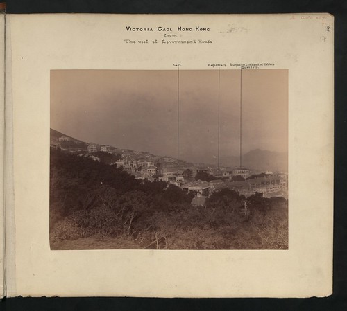
If there's a close-up view like the one above, that would be ideal. I haven't seen one yet though, so I'll settle for a distant but sharp view of Central from the east, where we can crop it to show the magistracy. Something like this photo in the UK National Archive (the Magistracy building is indicated by the middle vertical line):

CO 1069-446-17

Before we leave the Magistracy, another question I'm curious about:

Q6. Who was Arbuthnot Road named after?

It's the road that runs in front of the Magistracy building, linking Caine Road and Hollywood Road. Wikipedia suggests it was named after George Arbuthnot, but I'm not convinced by the explanation given there. If you'd like to join in the discussion about this, please see http://gwulo.com/node/15229.

Punishment: stocks and the cangue

One of the gentler punishments the magistrate could give out was to put you on display in the stocks or the cangue. The stocks fastened around the legs:

And to make sure there was no doubt about your crime, it was written on the board we can see resting on the criminals' laps.

The stocks were a familiar punishment in Britain, but the Chinese equivalent was known as the Cangue. A cangue is a wooden board in two halves that fasten around the neck. It had the stocks' embarrassment factor, but with added discomfort, and as a bonus the wide board meant you were unable to feed yourself:

This copy of the photo is displayed in the Virtual Shanghai website [6]. I was excited to see another copy of the same photo, with "convicts in Victoria Prison" written on the back. However we've since decided that the photo was taken outside Hong Kong, and mislabelled [7].

Then how about the photo we showed earlier:

It appears to show the cangue in Hong Kong - at least the policeman looks to be wearing a Hong Kong uniform. But we haven't found any good evidence that the cangue was used in Hong Kong after the 1840s. So this may have been a posed photograph for the benefit of a commercial photographer, rather than an actual event.

Q7. When was the cangue used as punishment in Hong Kong?

That would help answer the question about the photo above. If you know, please join the discussion about the use of the cangue at: http://gwulo.com/node/15121

The stocks and the cangue were certainly unpleasant, but harsher punishments were used too, included flogging and / or time in Victoria Prison.

Q8. Have you seen any photos of the flogging post?

I have been shown one that was in an exhibition, but haven't reached the owner yet. If you know of any photos, please let me know.

Victoria Prison

Although we're calling the site the Central Police Station Compound, the Police were relatively late to move in. The first buildings on the site were the Magistracy and the Prison (then called the Gaol).

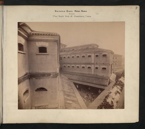
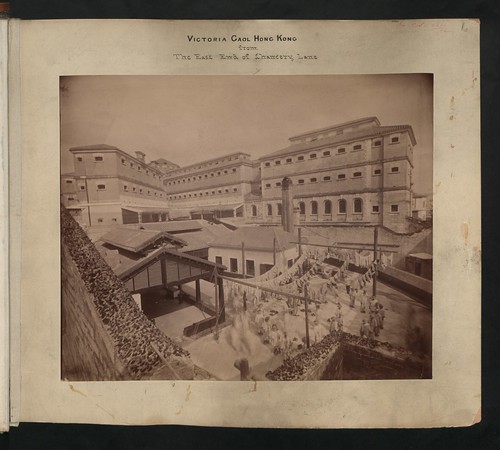
These 19th-century photos in the UK National Archive were taken from Chancery Lane, and show the prison buildings that were completed in 1858:

CO 1069-446-18

CO 1069-446-16

The two large buildings running left to right across the bottom photo are still standing today. They are the oldest remaining buildings on the site, and are known as "D Hall".

For a very different view of life in the prison, how about:

Forget the cangue, your punishment is ten-thousand twirls of the hula-hoop...

This photo is courtesy of local writer, Kate Whitehead. Kate lived in a flat overlooking the prison in the summer of 2005, just before the prison was decommissioned. Aware that this was a historic time, she left a digital camera on her windowsill to remind herself to take regular photos of whatever was going on in the prison yard.

She says the noise drifting up from the prison yard was surprisingly cheerful - more like a school-playground than anything else. At that time the female inmates were mainly young women from the mainland. They'd been working as prostitutes in Hong Kong, overstayed their visa, been caught and given a short sentence here. 

As far as Kate could tell, every inmate was issued a hula-hoop, as that's what they used to pass the time. The stylised photo above shows one of the more advanced inmates, showing off her double-hoop skills! (If the photo seems familiar, Kate exhibited them at the Fringe Club in 2005 as limited-edition prints.)


I hope you've enjoyed these. If you know of any more photos of the CPS compound (police station, magistracy or prison), or you can help answer any of the questions, please get in touch. You're welcome to leave a comment below, or please send me an email at:

Regards, David

Trivia:

One more photo of the stocks sent in by reader 'Moddsey', which he found on the internet some years ago:

Very obviously a posed photo! I'd be interested to hear the story behind it if anyone knows it.

References:

  1. Read about the background to this project at: http://gwulo.com/node/14719
  2. Harry Ching
  3. See the 1940 photo of Police and reservists, annotated with a fiull list of names, at http://gwulo.com/node/14770
  4. To find this photo, search the HKPL photo collection for cataloguing text: "Group pictured outside Pokfulam Police Station in 1913"
  5. To find this photo, search the HKPL photo collection for cataloguing text: "Former Central Magistracy, Arbuthnot Road, Central"
  6. http://www.virtualshanghai.net/Photos/Images?ID=25296
  7. Reasons the photo in [6] was unlikely to have been taken in Hong Kong: http://gwulo.com/node/15121#comment-23975

c.1920 Statue Square & Prince's Building

$
0
0

Where: As the postcard says, we're looking across Statue Square towards the original Prince's Building (the building on the left).

Who: The only living person in the photo is outnumbered by the statues that gave the square its name.

Over on the left is the grand cupola that was in the centre of the square, and housed a statue of Queen Victoria [1]. The cupola is long gone but you can still see the statue, now living in Victoria Park [2].

Another statue is this one of King Edward VII, standing on a simpler plinth:

When: We know the King Edward VII statue was unveiled in 1907, so the photo was taken after that.

Like photos of old Hong Kong? I'll be giving a talk on 24th April, showing a bunch of my favourite old photos, and telling their stories. Please click here for details.

Another clue is the faint, white line running along the hillside at the top-left corner of the picture:

That's Lugard Road, and it's the only structure from this photo that's still standing today. The road was built in two phases [3]. The first part was built in 1913-14, running from near the Peak Tram Terminus to just past the Bishop's Lodge. The section in the photo above was part of that, so the photo should be later than 1914.

The second phase took place during 1919-21. It extended the road to the junction with Harlech Road, completing the circuit around the Peak. Was that already finished when this photo was taken?

If you look up from the King Edward statue there's a white line at the very top of the picture. That could possibly be part of the road's second phase, but it's not clear enough to be sure.

Down from the Peak there's this cluster of buildings in mid-levels:

Do any of them help date the photo?

The last clue I can see is what's missing. In 1923 the HSBC's war memorial (a statue of 'Fame' [4]), and a statue of Sir Henry May were added to the square. We'd be able to see them from this viewpoint, so I believe the photo was taken before 1923.

I'll guess 1920 as the year this photo was taken, but please leave a comment below if you see any other evidence for or against.

What: Down in the right corner, there's what look like a stack of barrels and some sort of wagon:

Any ideas what they were used for?

Regards, David


Trivia: The original photos were black & white, but when printed as postcards they had several colours added to liven them up. Nothing fancy - just a few colours to choose from, and not always painted on very accurately:

The underlying photo is still clear to see though.

When I scan this type of postcard there's not as much detail available as there is with a photograph. But there is a lot more detail than we can get from a modern colour postcard. With a modern postcard, the coloured dots are visible at even a low level of zoom.

Does anyone know how these old postcards were printed, so they kept the detail?

References:

  1. Queen Victoria's statue in Statue Square
  2. Queen Victoria's statue today
  3. Construction of Lugard Road
  4. 'Fame' statue, the HSBC's war memorial
Date picture taken (to nearest decade for older photos): 
1920
Reference: 
NA002

c.1915 Des Voeux Road, Central

$
0
0

Where: As the postcard says, this is Des Voeux Road in Central. We're looking east from the junction with Pedder Street.

What: We can see the name of the building on the left, Alexandra Buildings:

It also shows a couple of company names: A. S. Watson along the bottom, and The China Mutual Life Insurance Co. in the window. Watsons the Chemist is still a well-known brand in Hong Kong, but it looks as though China Mutual was swallowed up by Sun Life in 1923 [1].

The tall building on the right of the postcard is the Hong Kong Hotel. Next to it is a row of three-storey buildings, running along Des Voeux Road to the junction with Ice House Street. Here's a map of the area from 1911 [2] (note that south is at the top);

Can you tell us anything about those five three-storey buildings, eg their names and when they were built? They used to be the grand seafront buildings along the praya, but after the big reclamation in the 1890s they've been overshadowed by these newer, taller buildings.

When: The photographer is up off the ground, probably looking out from a first- or second-floor window of the GPO (General Post Office) building. The GPO wasn't completed until 1911, so the date should be after that.

I've guessed this photo was taken in 1915, but can you spot anything that dates it more accurately? Please let us know.

Who: Plenty of people waiting to give you a ride in their sedan chair or rickshaw. And one gentleman taking his chair for a walk:

Regards, David

References:

  1. The Singapore Free Press and Mercantile Advertiser (1884-1942), 27 July 1923, Page 12
  2. Plate 3-4, Mapping Hong Kong book.
Date picture taken (to nearest decade for older photos): 
1915
Reference: 
NA008

Pillboxes on the mainland

$
0
0

Thanks to Rob Weir for the latest instalment from his records of British military sites in Hong Kong. Here's a map of their locations:

[Each red marker shows one pillbox. Click any marker to see its name. Click the name for more details, and to see if we have any photos of that pillbox.

Subscribers - if you can't see the map, please click here to view the web version of this page.]

Rob explains their background:

These pillboxes (PBs) were positioned to protect against attacks from the north through the passes and tracks in the Kowloon hills, as well as sites of possible amphibious landings. They ran in a line across the Kowloon Peninsula from the Texaco Peninsula (Kwai Chung), to Hung Hau on the Clearwater Bay Peninsula.

Construction commenced in 1935 and was completed in 1938.

Their size and shape varied with the number of firing loopholes, and local conditions, and with only one known exception (PB 119), all had 3 feet (91 cm) thick reinforced concrete walls and roof. Firing loopholes were protected by outward opening steel doors, and a steel door closed the entrance. Interior ventilation was through air shafts protruding above the roof, to internal ducts in some walls.

Many of the hillside PBs had long access tunnels to the entrance, and some were linked together by tunnels (indicated by a/b). PBs and tunnels were usually built in excavations in the hill, then covered with earth so only the loopholes and air shafts were visible. Those on flat ground did not have the tunnels, and were painted to resemble village houses.

Post war, the majority were either explosively demolished, leaving only piles of rubble, or removed entirely during New Town development. As of 2013, only three are known to survive largely intact: PB 313, 314, & 315.

Help make history: Can you spare thirty minutes? That's how long it takes to type up a page of Hong Kong's old Jurors Lists. You'll help create a valuable tool for everyone researching Hong Kong's history. Click here for details.

Rob's conventions in each pillbox's notes:

  • Names are those used at the time the pillbox was in use, and may vary from current naming eg. Lye Mun > Lye Yue Mun
  • "Year completed is:". Approximate means 'around that time'. Accurate means the year is accurate, but month & date are not.
  • "Condition at last visit:". Intact - it is still in the condition it was when used. Ruin - still visible, but damaged. Demolished - no traces remain.
  • "Date of last visit:" eg Jul-1998. When Rob last visited the site to check its condition.
  • "Ref:" Rob's reference number for this site.
  • "Other:" Anything else useful to know.

The layout of the pillboxes on the map shows a couple of other pieces of history.

First, they let us see the extent of the "Gin Drinkers Line". It consisted of trenches and pillboxes, built to defend against attack from the north. Looking at the map we can see it was made up of several defensive lines, rather than the single line the name suggests.

Second, we can see how much reclamation has taken place since the 1930s. Originally, the western pillboxes ran along the shoreline of Gin Drinkers Bay, which gave its name to the Line. The bay has long since been filled in.

Finally, if you look carefully you'll note several numbers are missing from the sequence of pillboxes: PBs 210, 211, 304, 305, 409, 410, 414, 422, 423, and 424. These are pillboxes that Rob doesn't feel confident he knows their location accurately, so they have not been shown on the map.

Regards, David

c.1920 Des Voeux Road, Central

$
0
0

Where: This is the same stretch of road we saw in the previous photo, but looking in the opposite direction. Here's the previous photo again, looking east along Des Voeux Road from Pedder Street:

In this week's photo we're looking west from the junction with Ice House Street.

When: In the previous photo I struggled to find anything that gave a firm date, but here the tram's roof helps us out.

Canvas roofs like this one were in use from 1913 on. In 1925, the fully enclosed upper-deck was introduced, though it took a few years to convert all the trams [1]. So I'll guess this photo was taken somewhere between those dates, around 1920.

Who: The couple of gentlemen in the foreground look to be waiting for the tram to stop and let them on.

Maybe they're heading to Causeway Bay, the destination shown on the tram's sign. They also had the option to take one of the rickshaws or sedan chairs we can see in the background, but the tram was a lot faster over longer distances.

What: This stretch of road started and ended with a hotel. The closest building on the right was the King Edward Hotel, on the corner of Ice House Street.

Next to it was the Alexandra Buildings, and beyond that the striped building was the General Post Office, the GPO.  (I think the photographer must have taken the previous photo from upstairs in the GPO building.)

The buildings on the left are five of the six buildings between Ice House Street and Pedder Street.

The tallest building in the distance is the six-storey North Wing of the Hong Kong Hotel, finished in 1892. I guess that the shorter buildings we can see are all older than that, since it would be unusual in Hong Kong to demolish a building and not build the new one as tall as possible!

Here's the 1911 map [2] again, showing this area (note that south is at the top):

If you know any more about those older buildings, eg when they were built and by who, please let us know in the comments below.

Thanks & regards, David

Trivia:

This postcard was published by "K.M. & CO. HONGKONG".

References:

  1. Tram generations.
  2. Plate 3-4, Mapping Hong Kong book.
Date picture taken (to nearest decade for older photos): 
1920
Reference: 
NA009

c.1900 View of beached sampans along the Yau Ma Tei shoreline

$
0
0

Where: Local historian Cheng Po-Hung has a very similar photo in his book "Early Hong Kong Kowloon's Peninsula". He describes it as:

Boats in front of Reclamation Street and boat people gathered along Sixth Street (Jordan Road).

That certainly sounds to be the right part of town, unless anyone disagrees with the ridgeline in the distance:

But I don't think he's got the names of the roads quite right.

Here's a map of the area in 1887 [1].

I think we're either looking at:

  • A. The view from Sixth Street (today's Jordan Road), across to Canton Road in front of Battery Street, or
  • B. The view from the end of Battery Street, looking across to Reclamation Street.

Looking at the 'ridgeline' photo again, there is an open area between the two terraces of buildings, with a tree growing there. Does anyone recognise the location? Other clues are that the shophouses in the foreground are only two storeys high, but the buildings behind them look to be three storeys high. Maybe the foreground buildings are older? 

Who: The title under the photo reads -

134. Characteristic groups on the shore at Kowloon. China.

I wondered if the people were posed for this photo, but I don't so. The photo in Cheng Po-Hung's book mentioned above shows the same boats and background, but different people. The photographer must have set up his camera and taken several photos over an extended period, waiting until people got used to him.

So some of the people are keeping an eye on the photographer, but if we take this group of children as an example, most are ignoring him:

The children and the ladies near them belong on the boats, with bare feet and plain, dark-coloured clothes. The men on the right look as though they are from a different "Characteristic group", wearing shoes and smarter clothes. The shorter man's white socks certainly suggest he doesn't spend time doing manual work.

When: The card has "Copyright 1902 by C. H. Graves." stamped on it. I'm guessing that the photo was taken a few years earlier than that, but I'm not 100% sure. The "C. H. Graves" was Carlton Harlow Graves, a photographer and publisher of Stereoview cards like this one.

Does anyone know when C. H. Graves visited Hong Kong?

What: A jumble of boats along the shoreline. These were homes too, so you see all the odds and ends they'd need for daily life:

As always, comments, corrections, and extra information welcome.

Regards, David

References:

  • Plate 4-2 (1887) Plan of Kowloon, from the Mapping Hong Kong book.
Date picture taken (to nearest decade for older photos): 
1900
Reference: 
A218

c.1961 Cine-film of Hong Kong

$
0
0

Many thanks to Tania Scott for sharing her family's cine films. 

They were taken by her father, David Scott, between 1960 - 1962. He was in Hong Kong with the RAF on a two year posting.

My favourites are the shots of boats where he's so low you think he must be whizzing along in a speed-boat, but then... well, see if you get the same surprise I did!

(Subscribers, you'll need to click here to visit the web version of this page to see the links to the videos.)

Regards, David

1920s View over western Hong Kong

$
0
0

Where: A couple of buildings on either side of the photo pin down where it was taken. First look down in the bottom right corner, where you'll see these buildings:<!--break-->

The long building across the middle is clearer to see in this photo (it's below the 'c' of the watermark - you can click it to get a zoomable copy):

It's the old hospital quarters building, on the corner of High Street and Eastern Street.

Next look across to the left side of the photo, where there's this light-coloured oval:

It's the roof of the gas holder that stood in Shek Tong Tsui, near where the market is today.

We're looking north over Sai Ying Pun and Shek Tong Tsui. There are also buildings from mid-levels in the foreground, and Stonecutters Island is away in the distance on the right.

Who: I wonder who'd have bought this view? It wasn't a popular subject for tourist postcards, so maybe it was someone who lived in this area.

When: This was a real photo sold as a postcard. Here's the back:

We've seen this stamp box design before. This type of paper was sold between 1910-1930 [1], giving a rough idea of the photo's age. Let's see if we can narrow it down further.

Take a look at the gas holder again:

Can you see a tower in front of the gas holder, attached to a large building? That's the Main Building at Hong Kong University, which was completed in 1912. Just above the right corner of the Main Building there's a small dome. That was opened in 1919, to hold the University Union. It's still standing today, now named the Hung Hing Ying Building.

Over on the right, at the bottom of the photo is another education building:

It's the main building of St Stephen's Girls' College, which opened in 1924.

Back in the centre, and again along the bottom edge, we've got these buildings:


Does anyone recognise them? They look newly built, so if they were finished after 1924 they'll narrow down the date even more. For now I'll guess the photo was taken in the mid- to late-1920s.

What: The view isn't as sharp as I'd like, partly due to the photo, and partly due to when it was taken.

The photo itself is over ninety years old, and showing its age. But even when it was new it wasn't as sharp as the other, older photo of this district shown above. Look at the shadows of the chimneys and you'll see it's late afternoon:

That makes for a darker photo, with more shadow. And since cooking was often done over firewood, there would be smoke in the air as families got dinner ready.


I've lived in and around Kennedy Town for over twenty years, so I'm always interested to see old photos of this side of Hong Kong. It wasn't a popular destination for tourists, which means there aren't many photos. If you know of any, please let me know in the comments below.

Regards, David

Trivia: Even though most of the buildings in these old photo are long gone, I like looking for signs of where they were. One example in this photo is an unusally shaped plot of land, that has been carried on into the present-day buildings.

Here are the buildings today, seen from street-level:


View Larger Map

And from above:


View Larger Map

Can you spot that same curved shape in the old photo?

References:

  1. "Azo" stamp box, with two triangles pointing up, and two pointing down: http://www.playle.com/realphoto/photoa.php
Date picture taken (to nearest decade for older photos): 
1925
Reference: 
A216

CPS project 2nd update: Magistracy & its magistrates

$
0
0

I'm searching for old photos of the buildings in and around the Central Police Station (CPS) site (click here for details of the project). In this update I'll look at the Magistracy building and the Magistrates who served there, then finish with the latest news on questions from earlier updates.


The Magistracy

When this was a working site, the fate of many of its 'guests' was decided by the Police Magistrates working here. Today the Magistracy building is part of the public face of the site, with its distinctive facade [1]:

Near the top of the building you'll see the year "1914". Maybe that reflects the optimism of builders across the world, as the building wasn't finished and opened for use until April 1915!

Though it's an old building, it's not the original Magistracy. The first Magistracy was a short distance southwest from the current building. It is shown on this map of the CPS site in 1845 [2]:

I hope your upside-down reading is ok - I've rotated the map so north is at the top like a modern map. You might also note the lack of any police station. Although we call it the 'Central Police Station' site, the police were the late-comers. It's original use was for a magistracy and a prison.

Like any Hong Kong map, this one was soon out of date. A new Magistracy building was built in 1845-6, and captured in this sketch dated 1846 [3]:

Here's a close-up, with the then-new Magistracy highlighted. The slope of Arbuthnot road is clear to see. 

I believe that the building further up the slope, on the very left edge of the sketch, is the first Magistracy building. It wasn't demolished when the new Magistracy opened, instead it was converted into the Debtors Prison.

The sketch was titled "View of Queen's Road and the Harbour Looking West from Murray's Battery". I haven't found any close-up views of this Magistracy building, but we can spot it in other views looking west across the city, like this 1869 photo:

Can you spot the Magistracy? Here's a close-up with it highlighted:

Q10. Are there any other similar photos or sketches you've seen that show the Magistracy?

Q11. Have you seen any close-up shots or interior views of it?

According to the 1898 newspapers [5], the building didn't age well:

One does not need to be fastidious in finding fault with the wretched place in which the Police Magistrate of Hong Kong exercises his functions. We feel pretty confident in saying that there is not a more wretchedly lighted, ill-designed, and badly ventilated police court in all the British colonies.

The room is abominably dirty, the ceilings are festooned with cobwebs and a fitting legend to place over the door of the place would be that which Dante described as adorning the portals of the nether regions.

It would last another 15 years though, before being demolished in 1913 to be replaced by the Magistracy building we see today.

The Magistrates

I'm also looking for photographs of the various magistrates that served in these buildings. They were a mixed bunch: Some had legal qualifications. Then after a time working as Police Magistrate they moved onwards and upwards through other court roles, with an appointment as Chief Justice the distant target.

But you didn't have to have a legal background to be a magistrate. Several of the Police Magistrates were Hong Kong Cadets, bright graduates from Britain's top universities who'd won a place as a Cadet in the far east civil service. An appointment as Magistrate was just one of many different positions they could expect to work in. Their goal was a senior role in the civil service, perhaps ending up as a Governor of a British colony. 

The length of appointment also varied. Some worked as Police Magistrate for several years. Others would just take the role for a few months, filling in the gaps between the permanent appointments.

Here are the magistrates who will probably get a mention in the history book.

Q12. Please do you know any photos or portraits of these men? Ideas for possible sources also welcome. (You can click any of the links above to see where I've already looked.)


Updates on earlier questions

I've received a few answers to the questions in the previous update:

Q1. Do you have any group photos taken in the parade ground?

Q2. Do you have any photos taken inside the buildings?

Thanks to Brian Coak for sending in photos for both these subjects.

Here's the first one:

Brian writes it is:

Chief Inspector Jack Hayward on parade and a shot of him with Governor Sir Alexander Grantham c.1950

We also get a view of the Barracks Block on the left, and the smaller Armoury to the right.

Brian also sent in a couple of photos of the Magistracy, which he knew well, as he "was a prosecutor at Court One during the 1967 Riots prosecuting riot cases." The first photo shows his old office:

And the second shows the entrance to Court One:

Thanks to Brian for sharing his photos with us.

Q9. What was the story behind this posed photo?

The answer to this question was a team effort: Adam identified the man as Sergeant A K Taylor. Then Moddsey found that Taylor was seconded from the Police to the Sanitary Department in 1911, which we think was the event being commemorated here. Finally reader "1314" confirmed the uniform styles match the year 1911. Thanks for everyone's help!


That's the end of the latest update. Please get in touch if you have any comments or corrections. I'd also love to hear from you if you know of any old photos showing the Police Station, Magistracy, or Prison on the CPS site.

Regards, David
 

References:

  1. Photo source: Hong Kong Public Library Photo Collection.
  2. Detail cropped from this map. Original held at the UK National Archive, their ref: WO 78-479.
  3. Sketch by Murdoch Bruce. The Hong Kong Museum of Art has a set of reproductions of Bruce's sketches available for purchase.
  4. Original held at the UK National Archive, their ref: CO 1069/444
  5. Clipping from The Hongkong Telegraph, March 9, 1898, page 2. Read the full article at: http://gwulo.com/node/15654
  6. The photo on the right is often said to show Wiliam Caine. But we think it's more likely to be his son. Read more about possible photos of William Caine at: http://gwulo.com/node/15764

Daughter reads father's diary of wartime Hong Kong for the first time - after a 70-year wait

$
0
0

Exciting news this week – we’ve heard from Rae, daughter of R E Jones. She has just read her father’s wartime diary [1] for the first time, having always believed it was destroyed in 1945.

Background

The diary starts at the end of 1940, when Jones was working as a prison officer in Stanley Prison. He often mentions his wife, Marjorie, who’d been evacuated to Australia, and his young daughter Rae. Rae had been born in Australia, so Jones hadn’t met her yet. A year later, events take a dramatic turn with the Japanese invasion of Hong Kong, and Jones taking part in the fighting at Stanley. He survives, and begins the long internment at Stanley Camp.

Jones isn’t physically hurt in any way during his internment – no beatings or torture as far as we can tell. But he has other hardships to bear. In the second half of 1942, his diaries record a close relationship developing with a lady he records by the initial G [2]. However she has doubts about whether her husband was killed in the fighting or not. Around Christmas time she breaks off the relationship, but Jones mentions her daily in his diaries, up until she leaves the camp, repatriated in 1943. 

Jones diary continues with records of routine daily life for the next couple of years, until in 1945 a new relationship develops. She is also initial G for most entries, though he once mentions her as Gwen [3]. After liberation, he begins the journey home to Britain, but with frequent mentions of Gwen, and also of his wife Marjorie who by then is back in Britain waiting to meet him. The diary ends with his arrival in Liverpool on 27th October, 1945.

You can’t finish the diary without wondering “What happened next?”

Diary

The diary only surfaced recently, after being hidden away for over sixty years. The first mention of it in public was this message from Alison McEwan, posted on 21st April, 2010 [4]:

I’ve recently started transcribing a diary in my family’s possession [...]

How my father Colin McEwan came by it we don’t know, but it turned up as we slowly went through my parents’ books.

It is a hardbacked notebook written in pencil from 28th Dec 1940 thro’ to 27th Oct 1945. […]

I have only reached early September 1942 but already I have references to a tiger and just today, $5 from the Pope.

[…]  I would dearly love to locate Rae Jones or her family so they could recover this piece of history.

Despite the efforts of several people, it was not possible to trace Rae’s whereabouts.

Then last year, I started posting daily entries from the diary as part of the “70 years ago” wartime diaries project [5]. His is the most consistent diary we have, with an entry for nearly every day of the internment.

I also hoped we’d hear from someone in Jones’ family, possibly Rae, or even someone from the next generation. I hoped it would be Rae, but was also unsure whether the news of her father’s relationships during internment would come as a shock.

Rae gets in touch

Then last Friday this comment appeared on Gwulo, with a request to get in touch:

I am Rae. The eldest daughter of Raymond Eric Jones. I have only today discovered this site and news of my father’s diaries.

I wrote to Rae immediately, attaching the typed copy of the diary that Alison had prepared.

Over to Rae:

What happened next?

When my father arrived back in the UK we met as a family for the first time at the home of friends of my mother in Lincoln.  We then stayed with my grandfather in Skegness until my father was passed fit to return to Hong Kong.  

It was during this time that G sent my father a gift of a rather splendid atlas (which I still have) together with a letter in which she told him he should remain with the wife with whom he had spent so little time and with the daughter he had not met until now.  My sister and have often talked about G (not even knowing her name) wondering who she was and what had happened to her. Her decision had such an affect on our lives. My sister (born after the war) and her lovely family would not have existed!

How deeply he loved G I can only surmise. I've read the diary now and know he was in a quandary about the future.  However, he still appeared to care for “Marj darling”!  

My mother read the letter and then the diary and in heartbreak mode destroyed their wedding photos, all their letters and the diary. However, we now know the diary survived and I can only believe that my father offered to carry out the destruction but instead sent it to someone for safekeeping. Perhaps to Steve ((E J Stevens [6])) with whom he appeared to be so close during his internment.  He was a prison officer also I believe.  Alison has told me her father was in charge of Stanley Prison for a short time after the war. Perhaps the diary was handed to him for safekeeping.  Steve is not someone I recollect when I was in Hong Kong.  

 My mother often expressed her sorrow at the loss of the diary.  She told me it was such a detailed record of camp life.  She was such an understanding person and accepted that liaisons were formed under these circumstances. It was my father who couldn't forget.

Back in Hong Kong, my father returned to Stanley Prison as a prison officer but very soon transferred to the Public Works Department. We moved to Kennedy Road and then to Wongneichong Road. He was a keen Mason and joined the Naval and Military Lodge.  He was a keen member of the Hong Kong RNVR and represented them at the RNVR Golden Jubilee parade in the presence of the Queen at Horse Guards Parade on 12th June, 1954.

What effect did internment have on your father?

My father never talked about his time in Stanley camp. There were a few people he refused to socialise with because of their selfish behaviour in camp.  This from my mother who never mentioned names because obviously I was at school with their children.

But it’s clear the man I grew up with was not the man who wrote the diary. Something changed him radically and I thought I would find answer in the diary.  I suppose what I have found is confirmation that losing G turned him into the silent, morose and impatient man I grew up with. 

People in the UK who knew him while he was courting my mother - it took him 4 years to persuade her to marry him and join him in Hong Kong - said he was a charming, loving and witty man who adored Marjorie. A lovely man. They assumed that his treatment by the Japanese was the cause of the change in him.  I don't get that impression from his diary. I feel he coped well with internment.  Others who were interned with him and were part of our social circle after the war were perfectly normal men who resumed life with their wives and children very happily.

He became a regular drinker, only after work and at weekends.  Not an alcoholic and only drank San Miguel.  He would call in at the Police Club or the Football Club en route home and get involved and forget to come home. 75 per cent of the time he arrived home too late for dinner. In the diary he mentions having a couple of glasses of wine with Steve and Mary which quickly affected him and remarked that he would have to be careful with alcohol.  

How did you find the diary?

I bought myself a mini Ipad and yesterday morning while lying in bed with my morning cup of tea was playing with it and bizarrely googled Rae Marjorie Jones Hong Kong and up popped R E Jones War Diaries.  I froze!

As a teenager I vowed that one day I would have heart to heart with my father to try to understand his attitude towards 'Marj darling and baby Rae'. Alas he died in 1957, before I had that opportunity. These diaries are that conversation. 

What else should we know about your father?

In the diary he does not mention the fact that he stitched a Union Jack into his mattress and slept on it for the duration of his internment. He was given the honour of raising that flag at Stanley when Hong Kong was liberated. His photograph was on the front pages of the UK papers and was included in the Pathe news reports. I have a copy of that photo hanging on my wall:  

The year before HK was handed back to China the Governor of Stanley Jail gave me permission to visit the actual site of the flag raising and a photo of me standing in the exact spot hangs alongside the photo of my father. The flag should have featured in the Hong Kong hand over but alas my mother had it buried with my father in his grave at Skegness. 

He also doesn't mention in the diary that our no.1 ah-mah, Ah Yam, known to us as Ga-so, smuggled food into him from time to time during his internment, and was the first person to greet him when he was liberated.  She remained with us until we finally left Hong Kong. 

He learned to speak, read and write Cantonese.  His Chinese staff adored him.  One Christmas we received so many live turkeys we could have run a turkey farm and he had to put a stop to their generosity!

My father was born in Lincoln on 8 December 1905.  He died in Hammersmith Hospital on 7 July 1957, aged 52. There was a memorial service at St John’s Cathedral in Hong Kong, and I attach copies of reports from the South China Morning Post (click thumbnail for a larger copy):

Do you plan to see the original diaries?

Alison is arranging for the diary to be returned to me.  My sister and I would like the opportunity to see the original and share it with our families, before deciding where the most appropriate place is for it to be kept.

Thank you to Alison, and to everyone that has helped put me back in touch with my father’s diary. I’d understood from my mother, who is now dead, that the diaries had been destroyed. I can hardly believe this has happened.


Thanks to Rae for so generously sharing her family’s story with us.

References:

  1. R E Jones’ wartime diary: http://gwulo.com/node/9660
  2. G: http://gwulo.com/node/15051 
  3. Gwen: http://gwulo.com/node/16147
  4. Message posted to the Stanley Camp Discussion Group: http://groups.yahoo.com/group/stanley_camp/message/961 
  5. Subscribe to the 70 years ago project to receive a daily email with diary extracts from 70 years ago today: http://gwulo.com/node/10010
  6. E J Stevens: http://gwulo.com/node/11744 

R E Jones' diary goes home

$
0
0

Yesterday I met Rae at her home in England, and delivered her father's diary:

Rae first got in touch two weeks ago [1]. By coincidence I'd already booked a flight to London for last week, so I asked if I could pay her a visit. That was arranged, then on Tuesday she mentioned that St Stephens College, who currently hosted her father's wartime diary in their museum, were planning to send it to her. Would it be posible for me to bring it by hand instead?

Yes - but only if they hurried, as I was flying out the next day! I received a call from Cortia at St Stephens first thing the next morning, and by lunchtime they'd delivered the diary to me. It went in to my hand-luggage, and I set off to the airport, feeling rather paranoid about losing it...

Yeterday I took a train from London out to meet Rae and her family. We had a good long talk about Hong Kong and Stanley, with Rae answering lots of questions. One question I'm always interested in is the long-term effects of life in camp, and whether those effects also ripple down to the internee's children and grand-children. It's a private matter, but Rae very generously answered that as well.

Rae has already told us that her father left camp a very different man from the one who began internment [1]. People who knew him before the war described him as a charming, loving and witty man. After the war he was still a popular and charming man at work and in social events, but at home he was very different - silent, morose and impatient.

As you'd expect, that made it very hard living in the same house. Rae's mother, Marjorie, would tell her "He wasn't always like this". Perhaps the memories of her loving husband helped her cope with the difficult home environment, hoping that somehow they could bring back that side of him. But Rae didn't have any happy memories to rely on. Indeed one of Rae's first memories of her father is from the day after his homecoming. Aged just 5, she picked up a strong sense of his dislike for her, that she'd done something wrong.

As she grew to a teenager, she felt he blamed her. That if she hadn't been born, he'd have carried on his relationship with Gwen. As she grew older and stronger she knew that one day she'd have to confront him, and ask just what was the problem. Unfortunately there was never a chance for her to ask these questions. Her father was diagnosed with cancer in 1957, and died just a few months later, with Rae still a teenager.

So for R E Jones, internment had a major, and damaging impact on his life.

His closest family also suffered, but fortunately not permanently. Rae's mother never married again, declaring she'd only ever loved one man. But she loved her daughters well, and lived to see Rae have her own, happy family, and become a leader in the local community.

Then what about the effects on later generations? I got the answer without asking. During my visit her son popped in, and later in the day we saw both grandchildren at different times. It was lovely to see their interest in the diary, and their care for Rae. The diary is an interesting part of their family history, but the events in it are just that, history.

A few words from Rae to wrap up:

You asked me to put into words how the discovery of the diary has affected me. It's brought back vividly all those feelings and emotions of long ago but not in a negative way. It's uncanny that my father's action in rescuing the diary from destruction and passing it on for safekeeping led it to arrive in the right hands.  Someone could well have come across it, not realised what it was and disposed of it.  As it was it was discovered by Alison's family who knew exactly what it was because of their own family's history relating to Hong Kong and to someone with interest enough to transcribe, contact the right people, and treasure it. Uncanny.  To me it's an unintentional gift from my father.

And it is a gift because it has opened up so many avenues with more to come.

If you knew the Jones family in Hong Kong, I'm sure Rae would be very pleased to hear from you.

Regards, David

References:

  1. Daughter reads father's diary of wartime Hong Kong for the first time - after a 70-year wait. 

Timeline:

1920sR E Jones serves in the Royal Navy, including serving on submarines.
1935

R E Jones meets Marjorie, and begins a long-distance campaign to woo, and eventually marry, her. She initially declines, as she is living with her widowed father, and feels he needs someone to look after him.

1935March. R E Jones begins work as a Prison Officer in Hong Kong.
1939

Marjorie relents, and agrees to marry Jones. She sets up a housekeeper to look after her father, then after marrying Jones in England, they return to Hong Kong together.

1940British women, including Marjorie, are evacuated from Hong Kong to Australia. She is pregnant.
1941

1st January. R E Jones begins writing his diary.

1941

22nd January. R E Jones' daughter, Rae, is born in Sydney

19418th December. The Japanese invade. Hong Kong is at war.
1941

25th December. Hong Kong surrenders. R E Jones becomes a prisoner at Stanley.

194530th August. At the ceremony in Stanley Camp celebrating their liberation, R E Jones raises the Union Jack that he's kept hidden in his mattress throughout the internment.
1945

Marjorie and Rae sail to the UK.

1945

October. R E Jones reaches the UK, and is re-united with his family. A parcel arrives from Gwen, a lady he'd been in a close relationship with in Stanley Camp. It includes a letter breaking off their relationship, and telling him he should stay with his wife and child. The family believe that R E Jones' diary is destroyed at this point, but somehow he managed to keep it.

1945-1957At some unknown date, R E Jones passes his diary to a third party. It ends up with Alison McEwan's father.
1947

R E Jones, Marjorie and Rae return to Hong Kong

1952R E Jones and Marjorie have a second daughter
1957

April. R E Jones is having trouble swallowing, he is sent for medical tests and is diagnosed with cancer. He is sent back to the UK for treatment, accompanied by all the family.

1957

July. R E Jones dies. The family would have liked to continue living in Hong Kong, but all their possessions had been sent to the UK. They settle in the UK.

2010Alison McEwan's husband is looking through her father's papers and finds this diary. She types up its contents and posts it to the Stanley Camp discussion list. She tries to trace Rae, but is unable to.
2012David begins serialising the diary, posting it here on Gwulo.com
2013

7 Jun. Rae is playing with her new iPad. She writes "I searched on Google for 'Rae Marjorie Jones Hong Kong' and up popped R E Jones War Diaries.  I froze!". She posts a comment on Gwulo.com and David contacts her by email.

Alison had passed the diary to St Stephens College to display in their museum. She contacts them to arrange its return.

201322 Jun. David visits Rae in England, and the diary is returned to the family.
Viewing all 427 articles
Browse latest View live